- Catalogs
- Trelleborg Marine and Infrastructure
- SafePilot User Guide
SafePilot User Guide

SafePilot User Guide
Version 3.2 introduces enhancements such as new chart features with distance marks, reduced clutter from obstructions, improved dusk and night mode colors, and the addition of miles per hour as a docking speed unit. It also includes GPS corrections via the SafePilot Server, bow crossing range and time visualization, optional docking speed warnings, and recording durations in the recordings list.
SafePilot is a customizable piloting tool with modules to meet various demands. The guide is divided into standard settings for customization and a detailed program description.
Users can personalize settings like ship information and measurement units. Registration requires an internet connection and a unique email for each device.
SafePilot supports instant zooming and fast response, allowing users to pan by dragging and zoom by pinching or double-tapping.
Users can set chart orientation to 'North up' or 'HDG up' and define views for quick access to frequently visited locations.
Displays standard navigational data such as heading, course over ground, and speed over ground in the top bar, with the conning position as the reference point.
Available for navigation, docking, and lock modes, accessible via the right-hand side panel.
Allows visualization of projected movements based on current data.
Displays data source information, including satellite data and battery status, with RTK offering the highest precision.
Users can configure vessel particulars and access a database of vessels from AIS for easy setup.
Details the positioning of GPS antennas on vessels, including length, beam, and heading offsets, to determine the position and orientation of the vessel's antennas.
Allows addition of notes on a vessel, shareable with other pilots if connected to a SafePilot server, and can be prioritized and sorted by date or priority.
Provides options for display settings, motion configurations, server connections, message center, and chart information, including modes for day, dusk, and night, brightness adjustments, and zones of confidence for data quality.
Describes the accuracy and coverage of surveyed data, categorized from A1 (highest accuracy) to U (unassessed).
Can be adjusted manually or automatically based on draught or under keel clearance, with tidal data integration available.
Configures motion vectors and alerts for docking speeds, shown based on the vessel's speed and turning rate.
Displays server connection details and messages from system components.
Information about installed charts and updates.
Allows switching between different operational contexts such as planning and navigation.
Tools for route planning, including route creation, fender lines, and annotations, with options for setting turn radius, max cross track distance, and speed limits.
Displays route information, including ETA, distance, and bearing to waypoints, and allows for meeting point calculations and CPA/TCPA visualizations.
Displays docking information such as transverse and longitudinal speeds, and docking angles relative to fender lines.
Provides speed and angle information for navigating locks.
Guidance for approaching locks, displaying distances from the vessel's centerline to the lock's centerline, with manual lock selection possible.
Displays transverse and longitudinal speeds, and distances to the turning basin circle, with calculations based on the ship's center.
AIS targets are shown with true shape if data is available; otherwise, a symbol indicates position. Target info can be accessed by tapping on the AIS target.
Allows users to virtually board another AIS target, indicated by a blinking 'V' on the chart.
Electronic bearing line and variable range marker allow users to measure bearing and distance from their vessel to a fixed location.
SafePilot connects to PRIMAR for chart updates, with charts and files exchangeable via iTunes.
Instructions for connecting to CAT ROT and CAT I units, including network setup and connection procedures.
Details on setting up and connecting to CAT II and CAT III units, emphasizing antenna placement for optimal performance.
Features like chart updates, shared annotations, alerts, and file synchronization when connected to a Port Server.
Describes the workflow for the MPX, a contract between pilot and master for piloting operations, including job creation, form completion, and submission for billing.
The job list provides an overview of received jobs, with options to activate, update, send to billing, or delete jobs, and allows viewing and editing job details.
Catalog excerpts
TRELLEBORG MARINE SYSTEMS SafePilot User Guide VERSION 3.2
Open the catalog to page 1
What's new in SafePilot 3.2 • Chart features: o Distance marks o Reduced snag/stump obstructions clutter o Improved dusk and night mode colors • Added miles per hour as docking speed unit option • GPS corrections through SafePilot Server • Added bow crossing range and time to info boxes and optional visualization • Optional docking speed warning • Recording durations shown in recordings list • Many different improvements and bug fixes
Open the catalog to page 4
Introduction to SafePilot The SafePilot software is a flexible piloting tool that can be extended by modules to fulfil a wide variety of demands. This user guide consists of two parts. First are the standard settings used to customize the program to the individual pilot’s preference. Second is a detailed description of the SafePilot program itself. App Settings To get started with SafePilot begin by setting your personal preferences such as ship information, units of measurement, etc. Go to the Home Screen — Settings — SafePilot and look at the options available. Registration Please note that...
Open the catalog to page 5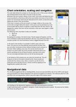
Chart orientation, scaling and navigation The scale label below the compass in the top right corner of the screen indicates the charted distance from center of screen to top of screen. Whenever the own vessel is shown on the screen, the screen will follow the own vessel, by default so that there will be the most visible chart area in front of the vessel. The vessel (and chart) may be relocated on the screen, so that the screen follows the vessel in this new location. If the chart is moved, so the own vessel is no longer visible on the screen, the screen will no longer follow the vessel. In this...
Open the catalog to page 6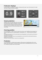
Fullscreen displays Fullscreen displays are available for navigation, docking and lock mode. Tap on the side panel on the righthand side to bring up the fullscreen displays. Vessel prediction Tapping the clock in the lower right-hand corner brings up the vessel prediction dialog. The dialog has a slider that controls the amount of time into the future to predict the positions of vessels. Scrubbing the slider will thus visualize the projected movement of active vessels based on their current data. Conning position The conning position – which is used as the origin of the motion vector, EBL/VRM,...
Open the catalog to page 7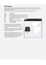
GPS status In the left side of the top bar the current status of the data source is displayed. Tap on it to see satellite data as HDOP, number of satellites, differential correction station ID etc. In this window you can also see the battery status of the CAT. With the status code shown in the Mode field, you can expect the following position accuracy. RTK: 1-2 cm (CAT III) AIS: Based on vessel instrumentation INV: Invalid data: No position available iPad: iPad's internal GPS The difference between SBAS and DGPS, is that in DGPS the corrections are coming from a shore station, and...
Open the catalog to page 8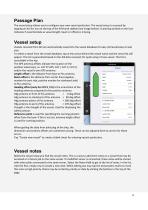
Passage Plan The vessel setup allows you to configure your own vessel particulars. The vessel setup is accessed by tapping on the list icon at the top of the left-hand sidebar (see image below). A warning symbol on the icon indicates if essential data as vessel length, beam or offsets is missing. Vessel setup Vessels received from AIS are automatically saved into the vessel database for easy retrieval/setup at next visit. To select a vessel from the vessel database, tap at the arrow behind the vessel name and the vessel list will appear. This list is generated based on the AIS data received,...
Open the catalog to page 9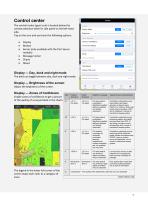
Control center The control center (gear icon) is located below the context selection wheel in side panel on the left-hand side. Tap on the icon and you have the following options: • Display • Motion • Server (only available with the Port Server module) • Message Center • Charts • About Display — Day, dusk and night mode The pilot can toggle between day, dusk and night mode. Display — Brightness of the screen Adjust the brightness of the screen. Display — Zones of Confidence Enable zones of confidence to get a picture of the quality of surveyed data in the charts. The legend in the lower left...
Open the catalog to page 10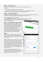
Display — Safety Contours Safety contours can be adjusted under the Display tab. Three modes can be chosen: - Disabled - Manual, selection of shallow contour and safety contour - Automatic, based on either a fixed under keel clearance or on a percentage of the draught. Here it is also possible to enable auto corrections of soundings based on tide. Display — Tidal data integration Tidal data can be integrated by a manual value, in form of a tide table or as live feed from tidal sensors. The tide integration options are handled under the Display tab in the control center. If tide is set to Manual...
Open the catalog to page 11
Server This tab is only shown if you are connected to a SafePilot Port Server. Here you can see the server address and enable or disable the internet AIS stream. Message center The Message center tab shows messages from various components for support use. About The About tab display system information such as the ENC user permit required for chart purchase, the license email used for registration (“assigned to”), version number and a list of activated modules. Charts The Charts tab display information about the installed charts and updates for charts.
Open the catalog to page 12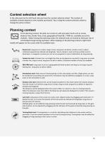
Context selection wheel In the side panel on the left-hand side you have the context selection wheel. The number of available contexts depend on the modules purchased. Tap or drag the context selection wheel to change the active context. Planning context In the planning context, the pilot can construct, edit and select tools such as routes, distance lines, fender lines, locks, geographical fixed EBL / VRM etc. available across the modules. When leaving the planning mode, the selected tools are locked to eliminate risk of unintended change during operation. When tapping on the planning context...
Open the catalog to page 13All Trelleborg Marine and Infrastructure catalogs and brochures
 Bollard infographic
1 Page
 Hydro-Pneumatic Fenders (HPNE)
10 Pages
 Foam Fenders & Buoys
24 Pages


Archived catalogs
 SafePilot brochure
20 Pages
 Fender Systems
86 Pages
 AutoMoor Brochure
24 Pages
 Multipurpose and Tug Fenders
44 Pages
 Solid SmartFender Factsheet
2 Pages
 Fender Application Design Manual
88 Pages
 Bollards
28 Pages
 Pneumatic Fenders brochure
28 Pages
 DynaMoor
20 Pages
 Rolling Fenders and Safety
18 Pages
 Ship-Shore Links Factsheet
4 Pages
 TRELLEBORG’S Tugger Winch
2 Pages
 Universal Safety Link
3 Pages
 Docking & Mooring
88 Pages
 Performance Monitoring
3 Pages
 SmartDock ® Display Board
4 Pages
 LNG Infographic
8 Pages
 SmartMoor Series II
7 Pages
 Surface Buoyancy
24 Pages
 TRELLEBORG DYNAMOOR
4 Pages
 Accessories
10 Pages
 SmartDAS Factsheet
2 Pages
 Capstans
4 Pages
 Remote Release System
6 Pages
 lload monitoring software
2 Pages
 Barometer Report 2
7 Pages
 lload monitoring systeme
5 Pages
 Guide - Fenders
8 Pages
 Mini Guide - Foam Fenders
5 Pages
 Barometer Report 3
16 Pages
 Hawser Hooks
6 Pages
 Whitepaper - Correction Factors
10 Pages
 Buoy Range Table
2 Pages
 SafePilot CAT XT System
2 Pages
 AutoMoor Datasheet
4 Pages
 Ship Shore Link System
3 Pages
 Combined ESDS & SSL
3 Pages
 Prelude LNG
1 Page
 Floating Fenders
48 Pages
 Emergency Shutdown Link
3 Pages
 Safepilot SmartPort System
16 Pages
 Docking and mooring
2 Pages


- Nautical buoy
- Ship winch
- Motorboat fender
- Dock fender
- Plastic buoy
- Floating boom
- Cylindrical fender
- Black fender
- Containment boom
- Trelleborg harbor fender
- Hydraulic drive winch
- Inflatable fender
- Manual ladder
- Trelleborg pier fender
- Nautical mooring buoy
- Nautical capstan
- Polyethylene buoy
- Sheltered waters boom
- Anchor chain