- Catalogs
- Stema Systems
- SILAS: Data acquisition, processing and interpretation tool sub-bottom profiling and seismic survey
SILAS: Data acquisition, processing and interpretation tool sub-bottom profiling and seismic survey
1 /2Pages

SILAS: Data acquisition, processing and interpretation tool sub-bottom profiling and seismic survey
1 /2Pages
Catalog excerpts
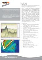
Data acquisition, processing and interpretation tool sub-bottom profiling and seismic survey The Silas software package has been developed to allow you to obtain the best quality data and easy access to multiple data types to best evaluate the subsurface conditions. The system covers the range of deep penetration to ultra-high resolution. Whether you look for general geology, cables or fluid mud surveys, the modular setup just fits your requirements. SBP section with borehole overlay SILAS is a complete data acquisition, processing and interpretation package to cover a wide range of tasks. It is source independent and can handle analogue or digital data from boomers, sparkers, parametric and chirp systems. A wide range of filtering and deconvolution techniques helps to optimize data quality. Automated and manual layer tracing, quick scrolling in the line and dynamic swapping layers over crosspoints helps to easily tie-in your interpretation. Absolute position and heave suppression tools provide direct export for contour mapping. For sub bottom classification and interpretation, borehole and map data can easily be integrated in the set. The modular set-up allows you to start with the basics and the program can grow with your needs. Key benefits Easy to use acquisition and processing package for echosounders, boomers, sparkers, etc. Modular package: Order just the tools you require and upgrade just as easily Interfaces and runs simultaneously with professional survey packages: a.o. Hypack, Qinsy Real-time data acquisition and quality control to reduce on water costs Integration of Multibeam, SSS and magnetometer maps Overlay of borehole and in-situ test data Calculation module for density calculation and subbottom sediment classification High quality data output and exchange with third party packages Typical Applications Pipeline/cable route surveys Wreck / object / cable detection Site investigations Mapping (polluted) sediment layers Low frequency echosounder dredging surveys Aggregate resource management Nautical depth iso-density mapping Planview with tracklines, boreholes and sonar data
Open the catalog to page 1
Data acquisition, processing and interpretation tool sub-bottom profiling and seismic survey specifications Module Acquisition Base package Digital high resolution seismic acquisition. Supports various A/D cards and UDP inputs/outputs. Real-time data and single trace monitoring Real-time density Module: Real-time output of depth values of bottom track and a bottomlayer: hard bottom or iso-density level (requires calibration) Processing Base package Digital seismic processing package with basic functionality for interpretation, layer tracing, navigation view, position and tide corrections. Export...
Open the catalog to page 2All Stema Systems catalogs and brochures
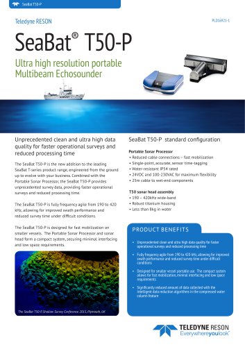 SEABAT T50-P
2 Pages
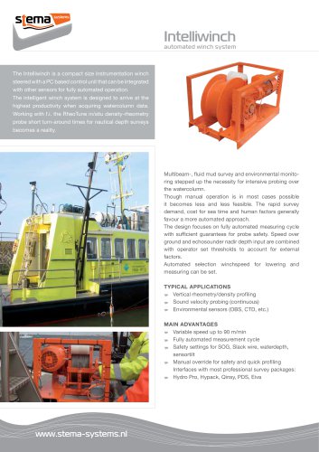 INTELLIGENT WINCH
2 Pages
 DensiTune Portable
2 Pages
 RheoTune
2 Pages