
- Catalogs
- Shark Marine Technologies
- SWATHPLUS-2011

SWATHPLUS-2011

SWATHPLUS-2011
The document describes an interferometric sonar system designed for acquiring high-resolution bathymetry and seafloor imagery over a wide swath. It meets international survey data standards, including IHO requirements, and is suitable for shallow water or low altitude operations.
Key Features
- High spatial resolution up to the swath edge with a low cost of ownership compared to beam-forming multibeam systems.
- Simultaneous pinging increases productivity and coverage, reducing survey and data processing time.
- Data compatibility with industry-standard applications like CARIS and QINSy.
- Lightweight, compact, and portable design with low power requirements (less than 25 W).
System Variants
- Three frequency variants: SWATHplus-L, SWATHplus-M, and SWATHplus-H, available in standard or splash-proof configurations.
- The 468 kHz system is deployable on ROV/AUV/ASV.
- System components include two transducers, a Transducer Interface Unit, a universal mounting kit, and a laptop with data acquisition and processing software.
Technical Specifications
- SWATHplus-L: 117 kHz, max depth 350 m, recommended working depth 300 m, across-track resolution 5 cm.
- SWATHplus-M: 234 kHz, max depth 200 m, recommended working depth 100 m, across-track resolution 2 cm.
- SWATHplus-H: 468 kHz, max depth 80 m, recommended working depth 50 m, across-track resolution 1 cm.
Applications
- Research and education (habitat mapping).
- Survey companies (navigable depth, route/site surveys, construction/dredging support, pipeline inspections).
- Utility companies (cable and pipeline surveys/inspections).
- Civil engineering (infrastructural surveys).
Contact Information
Systems Engineering & Assessment Ltd, SEA House, Building 450, Bristol Business Park, Coldharbour Lane, Bristol, UK, BS16 1EJ. Telephone: +44 (0) 1373 852000; Fax: +44 (0) 117 937 5088; www.sea.co.uk
Catalog excerpts
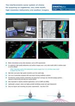
The interferometric sonar system of choice for acquiring co-registered, very wide swath, high-resolution bathymetry and seafloor imagery- SWAT Hp/us ■ Meets international survey data standards, such as IHO requirements. ■ Co-registered, high-quality bathymetry and seafloor imagery over a very wide swath width in shallow water USGS: "Operating swath of the bathymétrie system ranged from 15 to 20 times water depth in depths less than 15 m." ■ High data count gives high spatial resolution up to the swath edge. ■ Low cost of ownership compared with most beam-forming multibeam systems. Simultaneous pinging doubles productivity and along-track coverage over alternate pinging systems - reduced in-field survey and data turn-around efforts. ■ Data exportable to industry-standard applications, such as CARIS and QINSy. ■ Lightweight, compact, robust and highly portable facilitating simple and rapid deployment. ■ Does not require rack mounting; low power requirements - less than 25 W.
Open the catalog to page 1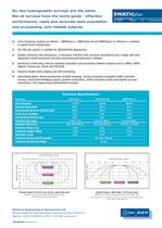
No two hydrographie surveys are the same. But all surveys have the same goals - effective performance, rapid and accurate data acquisition and processing, and reliable outputs. ■ Three frequency variants are offered - SWATHp/ws-L, SWATHp/ws-M and SWATHp/ws-H; offered in a standard ■ The 468 kHz system is available for ROV/AUV/ASV deployment. ■ System comprises two transducers, a Transducer Interface Unit, universal mounting kit and a laptop with data acquisition (swath processor) and data processing (grid processor) software. ■ Interfaces to third party, industry-standard acquisition and processing...
Open the catalog to page 2Archived catalogs
 SV-DCC Camera Controller
2 Pages
 PRO-MAG
2 Pages
 Cable Reel Bro
2 Pages
 LARS Spec
1 Page
 SDM-4000
2 Pages
 SM Yellowfin Spec
2 Pages
 SportScan Specs2
2 Pages
 SV-VOT Spec Sheet
2 Pages
 SV-GPS-OV1 Spec Sheet
2 Pages
 SV-VLC1 Spec Sheet
2 Pages
 SV-HDV Laptop Spec Sheet
2 Pages
 SV-Q10K SPEC SHEET
2 Pages
 SV-16HR SPEC SHEET
2 Pages
 SV-LL0003 Spec Sheet
2 Pages
 SV-14IR Spec Sheet
2 Pages
 SV-14R2 Spec Sheet
2 Pages
 Sea-Wolf2 Spec
2 Pages
 SV-HD-SDI Spec Sheet
1 Page
 STEALTH2 BRO
3 Pages


- Ship winch
- Underwater light
- LED underwater light
- Hydraulic drive winch
- Electric drive winch
- Intervention ROV
- Inspection ROV
- ROV umbilical cable winch
- Multibeam echo sounder
- ROV sonar
- Side scan sonar
- High-resolution sonar
- Underwater ROV light
- Portable sonar
- Launch and recovery system
- Bathymetry survey sonar
- ROV control console
- Hull inspection ROV