

RADAR

RADAR
Nobeltec provides advanced radar solutions that enhance navigation systems' safety and functionality. The InSight Radar 2 (IR2) integrates with computers, allowing radar images to overlay on charts for improved navigation.
Specifications
The IR2-HD2 17” Dome Radar is compact and lightweight, suitable for sailors and small power boaters. Key specifications include improved image resolution, low power consumption (45 Watts or less), a range scale from 1/8th mile to 24 miles, compact radome dimensions (17” x 8.5”), and Ethernet-based network radar with water protection certification (CFR-46).
Features
The radar integrates with Admiral™ and VNS™ software, offering high-resolution multicolor radar display, advanced target tracking with MARPA (requires heading sensor), multi-radar, multi-station network capabilities, and display compatibility with any size computer monitor.
Models and Technical Details
Several models are available:
- IR2-HD2 2kW 17” Radome: 2k Watts, 24 RPM, 9445 MHz frequency, 6.0º horizontal beam width, range up to 24 NM.
- IR2-4D 4kW 25” Radome: 4k Watts, 24/48 RPM, 9410 MHz frequency, 3.9º horizontal beam width, range up to 36 NM.
- IR2-4.3/IR2-4.4: 4k Watts, 24/48 RPM, 9410 MHz frequency, 2.5º/1.8º horizontal beam width, range up to 48 NM.
Power and Connectivity
All radars operate on 10.8 to 41.6 VDC and connect via a 10/100 ethernet connection. They are designed to withstand temperatures from -13º to 131º F and wind forces up to 100 knots.
Conclusion
Nobeltec's radar solutions offer robust, flexible, and high-performance options for marine navigation, catering to a range of needs from small vessels to larger setups.
Nobeltec offers powerful PC-based navigation software compatible with Windows® 7 and C-Map™ by Jeppesen® MAX Pro™ cartography. The software includes Tides & Currents® for North America and the NOAA Raster Chart Library for U.S. Coastal Waters.
VNS (Visual Navigation Suite)
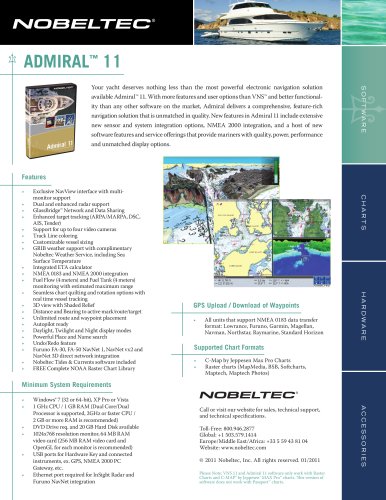
VNS™11 provides extensive sensor and system integration options, NMEA 2000 integration, and enhanced software features, offering mariners quality, power, and performance.
Admiral
Admiral™ 11 offers more features and user options than VNS™, with extensive sensor and system integration options, NMEA 2000 integration, and enhanced software features.
Network Configurations
Typical configurations include IR2 with a single computer and IR2 to a Nobeltec GlassBridge™ Network.
Catalog excerpts
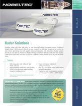
Radar Solutions Nobeltec radars add value and safety to your existing Nobeltec navigation system. Nobeltecs InSight Radar 2 (IR2) connects directly to your computer so that radar images can be overlaid on your charts, providing you with quality power, performance and unmatched display options directly on your desktop. Numerous display settings and options include a dedicated radar display, a split screen with radar and chart in separate windows or radar overlaid on top of your electronic Fully integrated with Admirai™ and VNS™ software High resolution multicolor radar display MARPA for advanced target tracking (requires heading sensor) Please Note: Radars and Nobeltec software are sold separately. Admiral software required for multi-radar and multi-station networking support. Chart overlay and stabilized radar presentation One-of-a-kind multi-radar, multi-station network capabilities Displays on any size computer monitor; viewing is not limited to a MFD display is the newest addition to Nobeltecs extensive line of full feature network based radars. The IR2-HD2 is compact and has a lightweight Radome antenna, perfect for sailors or small power boaters concerned about weight or power consumption yet who demand the most flexible and full-featured radar in its class. Dramatically improved image resolution (more than twice the resolution compared to the previous Nobeltec 2kW radar). Low power consumption: 45 Watts or less Excellent range scale: from as small as l/8th mile up to 24 miles Compact radome (17" x 8.5") with a standard 10 Meter (32.8') cable Ethernet based network radar Radome is certified to CFR-46 for water protection
Open the catalog to page 1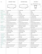
Peak Power Output Transmitting Frequency Beam Width Range Scales Presentation Mode Bearing Accuracy Guard Zone Range Discrimination Range Accuracy Pulse Length Power Consumption Voltage Supply Cable Length Options Operating Temperature Wind Force Water Resistance Dedicated: Course Up, North Up, Leg Up or Head Up Overlay: Course Up, North Up, Leg Up or Head Up FTC, Interference Rejection, Target Expansion Auto Calibrate, EBL, VRM, Zoon, Overlay, Gain, STC Omnidirectional - fully user-defined Within 25 Meters on 1/8 NM range Better than 25 Meters Better than 8 Meters or .9% of max range of scale...
Open the catalog to page 2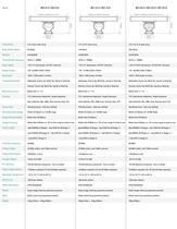
Peak Power Output Transmitting Frequency Beam Width Range Scales Presentation Mode Bearing Accuracy Guard Zone Range Discrimination Range Accuracy Pulse Length Power Consumption Voltage Supply Cable Length Options Operating Temperature Wind Force Water Resistance Dedicated: Course Up, North Up, Leg Up or Head Up Overlay: Course Up, North Up, Leg Up or Head Up FTC, Interference Rejection, Target Expansion Auto Calibrate, EBL, VRM, Zoon, Overlay, Gain, STC Omnidirectional - fully user-defined Within 25 Meters on 1/8 NM range Better than 25 Meters Better than 8 Meters or .9% of max range of scale...
Open the catalog to page 3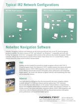
Typical IR2 Network Configurations IR2 With Single Computer IR2 to a Nobeltec GlassBridge™ Network Nobeltec Navigation Software Nobeltec Navigation Software and Solutions are the most powerful and easy to use PC-based navigation products available. The latest versions of VNS™ and Admirar*" are Windows" 7 compatible and work with C-Map™ by Jeppesen" MAX Pro™ cartography Both versions of the software also include the popular Tides & Currents" software for North America and the NOAA Raster Chart Library for U.S. Coastal Waters, Alaska, Hawaii, Puerto Rico, Guam and the Northern Mariana Islands....
Open the catalog to page 4All Nobeltec catalogs and brochures
 Nobeltec TimeZero v2.1
11 Pages
 accessories
2 Pages
 catch
catch2 Pages
 odyssey
3 Pages
 BathyRecorder
1 Page
 VNS™ 11
1 Page
 Admiral™ 11
2 Pages
 TimeZero Trident
3 Pages
 GPS 50W
18 Pages
 RADAR
RADAR2 Pages
 VNS 10
230 Pages
 ADMIRAL 10
230 Pages