Gold Catalogue
1 /2Pages

Gold Catalogue
1 /2Pages
Catalog excerpts

www.navionics.com Above graphic is representative of coverage areas, boundaries should not be considered precise. 16XG USA-EAST Entire US East coast including Martha’s Vinyard, Nantucket, Hudson River, Lake Champlain, Long Island Sound, Block Island, Delaware Bay, Chesapeake Bay, Bermuda, Northern Bahamas to Great Exuma Island, Cay Sal Bank, Florida Keys, Dry Tortugas, Fort Myers and Tampa Bay. 15XG USA-CENTRAL Includes US portion only of the Great Lakes, Lake Champlain, Finger Lakes, Ohio River, Cumberland River, Kanawha River, Allegheny River, Green River, Illinois River, Missouri River, Tennessee River, Mississippi River, Arkansas River, Green River, Tennessee-Tombigee Waterway and entire Gulf of Mexico. 14XG GR LAKES & MARITIMES Entire Great Lakes, St Lawrence and the Canadian Maritimes, including Lake of the Woods, Rainy Lake, Lake Champlain, Trent Severn Waterway, Ottawa River, Rideau Waterway and the Finger Lakes. 13XG BRITISH COLUMBIA Puget Sound, British Columbia, Vancouver Island from Puget Sound and Juan de Fuca Strait including Strait of Georgia, Johnstone Strait, Queen Charlotte Strait, Cape Flattery, Hecate Strait and Queen Charlotte Islands. NAVIONICS INC 6 Thatcher Lane, Wareham, MA 02571 tel. +1 508 291 6000 • 800 848 5896 • fax +1 508 291 6006 [email protected] NAVIONICS UK PO Box 38, Plymouth, PL9 8YY tel. +44 01752 204735 • fax +44 01752 204736 [email protected] NAVIONICS AUSTRALIA 1B/408 Victoria Rd, Gladesville, NSW 2111 tel. +61 (0)2 9816 7150 • fax +61 (0)2 9817 3966 [email protected] ©2007 Navionics Spa, Italy BRO/XL9/EN/0307 Authorized Dealer Multiple XL3 charts packed in one XL9: same great detail, same great price! New XL9-Size Charts! Clearer Charts The Best Detail Paper-like chart detail with user selectable safety contours, wreck database, tides and currents, spot soundings, port plans and services Full Seamless Technology No clutter, no holes, no discontinuities. WARNING: The electronic chart is an aid to navigation designed to facilitate the use of authorized government charts, not to replace them. Only official government charts and notices to mariners contain all the information needed for safe navigation, and as always, the captain is responsible for their prudent use. www.navionics.com Key features of Gold Charts include shaded depth contours, coloured navigation light sectors and real-world shapes and colours of buoys and navaids to provide for clearer harbour approaches. Spot soundings, tide and current data, detailed port plans, port service guides give the user full information to navigate more safely and easily. The new X-Plain™ feature that translates navigational symbols into plain language everyone can understand with just a click of the cursor. Gold XL9 Charts are available on preprogrammed CF and SD cartridges that are ready to use right out of the box… no CD’s, downloads or unlock codes required. Just Plug-and-Play into your plotter! This product is produced, in part, from the products and with the agreement of Imray (UK) and the hydrographic offices of Australia, Denmark (KMS), Finland (FMA), France (SHOM), Greece, Italy, Norway, South Africa and the United Kingdom. These hydrographic offices have not verified this product and do not accept liability for its accuracy. WORLDWIDE CATALOGUE Why Our Charts Are Clearer Full Seamless Technology means fast, smooth, seamless transition from one official chart to another regardless of scale. Fishermen and navigators alike can zoom-in revealing a greater level of detail and never worry about clutter or holes in the coverage. for Serious Fishing & Cruising The Finest Plotters Leading manufacturers choose genuine Navionics cartography REVEAL GREATER DETAIL WITH EVERY ZOOM, AS SHOWN HERE Navionics goes further than just digitizing official paper charts; we integrate them seamlessly and ensure every zoom level is perfectly clear and easy to read. Same great detail! Same great price! The Easiest to Use Plug-and-play cartridge is ready to use, no CDs, download or unlock codes required AMERICAS 17XG MID AMER & CARIBBEAN Southern California and the Channel Islands, Baja, Mexico, entire Caribbean, Venezuela, Cuba, entire Bahamas, southern Florida to Fort Pierce and Fort Myers. NAVIONICS SPA Via Fondacci 269, Z.I. Montramito, 55054 Massarosa, Italy tel. +39 0584 329111 • fax +39 0584 962696 [email protected] Gold Gold Unbeatable Coverage! For a complete list of equipment compatible with Navionics charts please consult your marine electronics dealer, or our website: www.navionics.com 11XG NORTH & EAST CANADA St Lawrence River, Lake Champlain, Gulf of St Lawrence, Nova Scotia, Labrador, Newfoundland And Nunavut. From Cornwall And Montebello ToBay Of Fundy to Lake Champlain, including Sable Island, Ies De La Madeleine, Prince Edward Island, Anticosti Island, Cape Breton Island, IlesDe La Madeleine And Strait Of Belle Isle. 18XG SOUTH AMERICA South America Northeast, Northwest, Brazil, Argentina, Chile from Trinidad and Tobago to Cape Horn to Isla Hanover, including Ilhas Martin Vaz, Ilha da Trindade, Atol das Rocas, Arquipelago de Fernando de Noronha, Golfo San Matias, Golfo San Jorge, Bahia Grande, Strait of Magellan, Falkland islands, South Georgia, Panama, Cape Horn, Bahia Blanca including Archipielago de Colon and Cape Disappointment. Gold 12XG USA-WEST & ALASKA Covers entire US West Coast and Baja to Cabo San Lucas, Hawaii and Alaska from Dixon Entrance to Northern Alaska including Dutch Harbor and the Pribilof Islands. Gold
Open the catalog to page 1
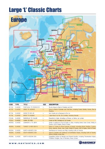
Gold Gold Gold Gold Above graphic is representative of coverage areas, boundaries should not be considered precise. EUROPE & AFRICA 20XG GREENLAND & ICELAND Greenland West, Greenland South, Iceland. From Northumberland Oe to Kap Farvel to Nathorst Fjord. Including Scoresby Sund, Disko Bugt, Melville Bugt, Nuuk in Greenland and Faroe Islands, Shetland Islands,Orkney Islands, Hebrides and North West Scotland from Kyle Rhea to Helmsdale. 21XG FINNISH & RUSSIAN LAKES Inarijarvi, Porttipahdan Tekojarvi, Lokan Tekojarvi, Miekojarvi, Emijarvi,Vahonselka, Mourujarvi, Yli Kitka, Kiantajarvi, Vuokkijarvi,...
Open the catalog to page 2All Navionics catalogs and brochures
 Humminbird Models
2 Pages
 Northstar Models
2 Pages
 Raymarine Models
2 Pages
Archived catalogs
 Classic Charts Catalogue
2 Pages
 NavPlanner Catalogue
2 Pages
 Platinum+ Catalogue
2 Pages
 Platinum Catalogue
2 Pages