FLEET-DEQ (Monitoring Control and Rescue System)

FLEET-DEQ (Monitoring Control and Rescue System)
The FLEETDEQ system is designed for fleet tracking, offering functionalities such as obtaining and storing vessel position, course, and speed data, event communications, and emergency notifications. It supports vessel search, route calculation, and displays information in tabular form. The system uses PostgreSQL for data management, enabling custom processing programs.
System Configuration
Configured as a web server, the system is compatible with browsers supporting DHTML and CSS, accessible globally without specialized software installation. It operates on Linux, providing security against viruses and unauthorized access.
System Users
Users are categorized by access rights: system administrator, data administrator, privileged user, and simple user, each with specific permissions. Users manage vessels within their group.
Reception of Communications
The system receives vessel position communications via email (SMTP) and checks mailboxes (POP3). It supports integration with other systems and future communication sources like SMS and Thuraya.
Work with the System
The interface includes a chart space and information window, allowing chart management, vessel information viewing, and display adjustments. It supports various chart formats and user-added charts.
Chart and Route Management
Users can adjust chart display, manage vessel routes with turning points, and use tools for distance and route calculations.
Vessel and Group Functions
Users can view and edit vessel information, including emergency status. Group functions offer an overview of all company vessels with sorting and search capabilities.
Playback and Options
The system features playback for displaying vessel positions over time, with customizable parameters and chart layout options.
Logoff Function
Users must log off to ensure secure access management.
Catalog excerpts
FLEETDEQ (Monitoring Control and Rescue System) 1. Features and Capacities of the System The System is intended for the tracking of the group of vessels, belonging to the company. The System allows to: ● to obtain and to store communications about the position, the course, the speed of the vessel and so different texts communications about events on the vessel, in the production activity and so on. ● to calculate the current position of the vessel on the basis from the last communication about the course and the speed. ● to enter communications about the change of the vessel's state (in sea, in repair), communications about urgencies, operator's short notes about the vessel. ● to enter and to correct information about the vessel (type, name, call sign, email and so on). ● to reflect communications obtained from the vessel and the communications entered by the operators in form of table. ● to correct communications about vessel's position. ● to reflect company's group of vessels in form of table. ● to search for company's vessels, the nearest of the selection (it reveals loxodromic distance and course). ● to display past or future company's vessels moving on basis of the obtained information, during any period with a given speed. ● to reflect company's vessels position on the chart. ● to reflect company's vessels additional information (depth underneath vessel and so on) on the chart. ● to reflect time according to any time zone. ● to select individually the vessel's outline (icon) and the vessel's outline colour for chartping on the chart of each company's vessels. ● to calculate the distance and the course between two points (vessels) from the chart. (Distance calculator) ● to calculate the route of the vessel's motion from the chart (distance and course between the rotary points, the addition/removal of rotary points to any route place, the overall route length) (routes calculator). ● to note the vessels on the chart for which is entered the communication about the emergency. ● to note the fact of entry of the vessel in one of the ports (ports data base consist of more than 4000 ports). ● to search for the selected vessel on the chart, to centre the chart according to the obtained vessel. ● to reflect information to reflect the information of the noted vessel on the chart, to select the vessel on the chart. ● to reflect the chart of diverse sizes (now, are supported ARCS and BSB sizes, subsequently is planned the S57 support). ● to add into the system new charts which interest the regions user. If the user doesn't have the chart of any region, the socalled Synthetic chart, made on basis of the heights of the earth's surface with a step of 30 seconds, is given to the user. DBMS (Data Base Managment System) PostgreSQL is used for storing of communication and information about the vessels, which makes possible for user to develop and to use its own programs for processing of this information.
Open the catalog to page 1
2. System Configuration The System is built according to the configuration of the final customer WEB server. Any WEB browser, which supports standards DHTML and CSS, particularly Internet Explorer 6.0, Netscape 7.0, Mozilla working under the control of the operating systems Linux and Windows, can appear as a client. The System does not require the installation of any specialized programs at the customer work sites. Work sites can be territorially spread; it is also possible to work with the system through the global Internet network. Server computer is under the control of the operating system Linux. In case of obtaining communications about the vessel's position by email, the server must...
Open the catalog to page 2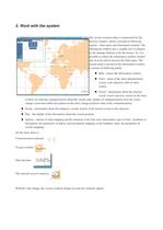
5. Work with the system The system customer place is represented by the browser window, which is divided in following regions chart space and information window. The information window has a variable size (it changes by the manager buttons or by the mouse). So, it is possible to reduce the information window (turned into an icon) and to increase the chart space. The system menu is present in the information window, it consists of following points: ● Hide reduce the information window. ● Chart menu of the chart administration (zoom, scale selection, shift of chart centre). ● Vessel information about the selected...
Open the catalog to page 3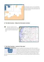
In the information window, are also located buttons for the monitoring of the route construction and also switching on/switching off the position indicator and the distance calculator. 6. The Hide function Hides the information window The point is intended to turn the information window into an icon with purpose to maximize the chart space. A click on the icon opens the information window again. 7. The Chart function control of the chart The point is intended for the chart mapping control. Here, it is possible to change the scale of the reflected chart, using Zoom+ and Zoom buttons and/or...
Open the catalog to page 4
8. Control of the Mouse ● Click on the left mouse button to place the indicator ● The double click to centre ● Click on the right mouse button to centre ● with the decrease ● The move with the pressed left mouse button the part (region) selection 9. Control of the buttons Cursor movement + space c The indicator shift (+ accelerated) Centering on the indicator To switch on/switch off the distance calculator Enter To add a point into the scale calculator DEL To remove a point from the scale calculator f To find the selected vessel j The information window boundary downward k The information window boundary upward...
Open the catalog to page 5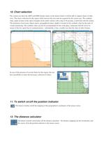
10. Chart selection The system can show the ARCS and BSB formats charts; in the nearest future it will be able to support charts of other sizes. The charts collection for the region which interests the user must be acquired by the system user. The synthetic chart, made on basis of the chart of heights of the earth's surface with a step of 30 seconds, is delivered with the system. The minimum of necessary objects (ports, geographical names, depth) is located on the synthetic chart for the tasks of vessels monitoring. The synthetic chart can also be recommended for the work place, connected with the server by...
Open the catalog to page 6All NAUDEQ catalogs and brochures
 ARPA RADAR SIMULATOR
2 Pages
 VR-DYPO (DPS Simulator)
2 Pages
 COMMAND-DEQ
15 Pages
 MASTER-DEQ 10/20
2 Pages
 LOAD-DEQ
3 Pages
 PRESSURES TRANSMITTERS
1 Page
 SONAR LEVEL GAUGING
1 Page


- Ship software
- Level switch
- Ship level switch
- Storage tank level switch
- Ship simulator
- Nautical navigation simulator
- Integrated bridge system
- Ship integrated bridge system
- Nautical ECDIS
- Ship ECDIS
- Dynamic positioning system (DPS)
- Loading software
- Ship dynamic positioning system (DPS)
- Container software
- Ultrasonic level switch