
Catalog excerpts
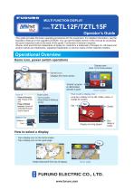
MULTI FUNCTION DISPLAY Model This guide provides the basic operating procedures for this equipment. For detailed information, see the Operator’s Manual in the supplied CD-ROM. You can get the latest version of the manual by accessing the quick response code at the back of this guide. Connection of sensors required. iPhone, iPod and iPad are trademarks of Apple Inc. Android is a trademark of Google Inc. All brand and product names are trademarks, registered trademarks or service marks of their respctive holders. Operational Overview Home icon, power switch operations Display icons (max. 16 on home screen) Home icon Displays the home screen. Lists “eGuide” provides an abbreviated operator’s guide. How to edit a display icon Power switch Power off function only: Powers off this unit. Power off linked function: Powers off all NavNetTZ touch2 units in network. Home screen - Turns on power - Shows [Power & Brilliance] window. Long tap a display icon to edit, delete, resize, or change its location. Edit Display icon long tapped How to select a display - Tap a display icon on the home screen. - Tap a display icon on the quick page. Tap Swipe downward from top of display Quick page
Open the catalog to page 1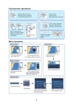
Drag, swipe - Select an item on a menu. - Select an object to show the corresponding pop-up menu. - Move the chart. - Scroll the menu. - Show slide menu, layer menu. - Zoom in, zoom out the plotter and weather displays. - Change the range on the radar display. Do the function assigned to [Function Gesture] in the [Settings] - [General] menu. Tap operation also available. Change the viewpoint position on the 3D display. Menu operation Pop-up menu Tap screen (applicable point, object, etc.) Layer menu Tap the required function. (”>” indicates additional options.) Swipe upward from the bottom...
Open the catalog to page 2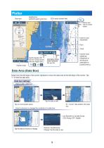
Plotter Heading line (yellowish-green solid line) Data area COG vector (broken line) Tap Ret Return own ship to screen center Inactive route (expanded) Point Boat icon Track Display range Switch between 2D and 3D. (Drag upward with two fingers also.) Inactive route (sleeping) (Departure or arrival point, selectable on [Layers] menu.) Orientation Mode Switch between NU and HU. Data Area (Data Box) Swipe from the left edge of the screen rightward to show the data area at the left edge of the screen. Tap “<” to hide the data area. Data box settings How to add a data box Tide Information Ex....
Open the catalog to page 3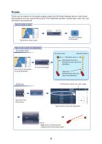
Points Points can be entered on the plotter display (radar and fish finder displays also) to mark important locations such as a good fishing spot. Point attributes (position, symbol type, color, etc.) are recorded to the points list. How to enter a point The point is entered on the screen. Tap where to enter a point. How to set a point as destination On-screen point Selected location On-screen point Destination point Red dashed line (thick): Indicates course to go to the destination. If a point was tapped. Tap a point or the location to set as destination. Yellow line: Shortest course from...
Open the catalog to page 4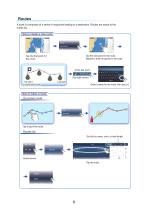
Routes A route is comprised of a series of waypoints leading to a destination. Routes are saved to the routes list. How to create a new route Tap the next point for the route. Repeat to enter all points for the route. Tap the first point for the route. At the last point (Top right corner) 1st point (route start point) Last point Enter a name for the route, then tap [ ]. How to follow a route On-screen route Routes list Sort list by name, color, or total length. Home screen Tap the route.
Open the catalog to page 5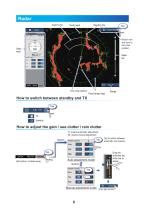
Radar Guard zone Heading line Data area Radar Control Return own ship icon to own ship position. Fixed range rings How to switch between standby and TX Tap TX X How to adjust the gain / sea clutter / rain clutter “A” means automatic adjustment “M” means manual adjustment Radar Control Tap to switch between automatic and manual. A Auto adjustment mode (At bottom of data area) Drag the slider/tap the slider bar to adjust. Manual adjustment mode (Top right corne
Open the catalog to page 6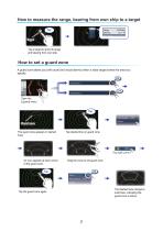
How to measure the range, bearing from own ship to a target Tap Target Tap a target to show its range and bearing from own ship. How to set a guard zone A guard zone alerts you (with aural and visual alarms) when a radar target enters the area you specify. 250 Radar Control Open the [Layers] menu. Guard zone The guard zone appears in dashed lines. Tap dashed line on guard zone. An icon appears at each corner of the guard zone. Drag the icons to set guard zone. The dashed lines change to solid lines, indicating the guard zone is active. Tap the guard zone again.
Open the catalog to page 7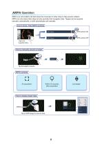
ARPA Operation ARPA is an anti-collision aid that tracks the movement of other ships to help prevent collision. ARPA not only tracks other ships but also provides their navigation data. Targets can be acquired manually, automatically, or both automatically and manually. How to show, hide ARPA symbols 250 Radar Control Open the [Layers] menu. How to manually acquire a target Tap Acquire ARPA symbols Within 30 seconds after acquisition Lost target How to display target data Tap 4 ARPA symbol Tap an ARPA target to show its data.
Open the catalog to page 8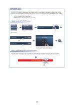
CPA/TCPA alarm The CPA/TCPA alarm releases an aural alarm and a visual alarm (message in Status bar) when both the CPA and TCPA of a tracked target are equal to or lower than the CPA/TCPA alarm setting. CPA: Closest point of approach TCPA: Time to closest point of approach Set the alarm value, then tap [ ]. How to acknowledge the CPA/TCPA alarm Tap the alarm message (top of screen) to acknowledge the alarm and stop the aural alarm. CPA/TCPA Alarm
Open the catalog to page 9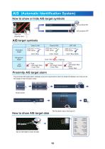
AIS (Automatic Identification System) How to show or hide AIS target symbols ON AIS symbols ON s OFF AIS symbols OFF Open the [Layers] menu. AIS target symbols Class A AIS Activated target Color: Blue Dangerous target Lost target Color: Green Color: Red Color - AIS target: Blue - Cross: Red Color: Blue (filled) Color - AIS target: Green - Cross: Red Color - AIS target: Blue (filled) - Cross: Red Proximity AIS target alarm The proximity AIS target alarm releases aural and visual alarms when the distance between own ship and an AIS target is near the alarm value. Set the alarm value, then tap...
Open the catalog to page 10All FURUNO France catalogs and brochures
-
 FCV-1150/295
2 Pages
-
 GP_1871F_1971F
2 Pages
-
 NAVpilot-300
2 Pages
-
 Model BR-500
6 Pages
-
 Felcom 18 / Felcom 19
2 Pages
-
 NX-700A/NX-700B
4 Pages
-
 RD-20/50
4 Pages
-
 Model FI-70 instrument
2 Pages
-
 FDM-3200/3300/3200-BB
10 Pages
-
 GPS navigator GP39
4 Pages
-
 GP-170
4 Pages
-
 NAVnet TZ touch
20 Pages
-
 NAVnet 3D
40 Pages
-
 FCV-2100
6 Pages
-
 FCV-1150
2 Pages
-
 FR-8045/8065/8125/8255
2 Pages
-
 FAR 1513BB 1523BB
4 Pages
-
 MODEL 1835 1935 1945
6 Pages
-
 MODEL 1815
4 Pages
-
 DRS4W
DRS4W4 Pages
-
 NAVnet TZT touch 3
12 Pages
-
 NAVnet TZ touch2
20 Pages


Archived catalogs
-
 Brochure v100GX
2 Pages
-
 DFF1-UHD
1 Pages
-
 FCV627
3 Pages
-
 navpilot 700 / 711 / 720
3 Pages
-
 T Z touch
10 Pages
-
 fax 410
2 Pages
-
 FAX 30
2 Pages
-
 FELCOM250/500
8 Pages
-
 Felcom 15
2 Pages
-
 GPS5
GPS51 Pages
-
 GP33
GP332 Pages
-
 GP32
GP322 Pages
-
 VR-3000
4 Pages
-
 IC350
IC3502 Pages
-
 FEA 2017 2807
4 Pages
-
 A50
A506 Pages
-
 FA 30
FA 302 Pages

