Catalog excerpts

collision avoidance See and be seen by other vessels Navigate safely in poor visibility Be alerted about possible collision early on WIRELESS DATA SOLUTIONS
Open the catalog to page 1
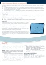
AIS – Automatic Identification System An Automatic Identification System (AIS) is a location and vessel information reporting system that greatly contributes to safety at sea: • It is used on ships to identify and locate other AIS equipped vessels by electronically exchanging data with them. • AIS data is also exchanged between the vessel and AIS land stations which allows maritime authorities to track and monitor vessel movements along their coasts. • AIS stations called ATON (Aid TO Navigation) help vessels by transmitting locations of coastal threats, like shallows, reefs and islands,...
Open the catalog to page 2
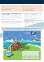
BlueAIS® automatically shares your vessel’s static information about: • Call sign and name • MMSI (Maritime Mobile Service Identity) • Type and dimensions BlueAIS® is an essential safety and navigation device for collision avoidance since it continuously receives information from all Class A and Class B equipped vessels and displays this information on the standard chart/AIS plotter or PC. At the same time BlueAIS® will automatically transmit the position to all AIS equipped vessels or land stations. BlueAIS® is a vital navigation tool in poor visibility conditions due to bad weather and...
Open the catalog to page 3
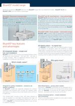
BlueAIS® model range Beside the exceptional BlueAIS® premium, the BlueAIS® range offers two additional models - BlueAIS® ext-B and BlueAIS® 12W, both with distinct advantages. BlueAIS® Premium transponder BlueAIS Premium is a fully integrated AIS solution in a single, open air installable housing. The VHF and GPS electronics and both antennas are integrated on or inside an IP69 grade waterproof enclosure. BlueAIS® Premium’s design reduces overall cabling from typically 3 cables run for the common AIS design to one cable only. ® BlueAIS® ext-B: new feature – new advantage BlueAIS® ext-B...
Open the catalog to page 4
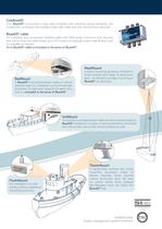
ConBoxAIS Your BlueAIS® connection is easy and compliant with electrical wiring standards; the ConBoxAIS connection box enables water tight cable and wire connectivity (optional). BlueAIS® cable It’s a weather and oil resistant shielded cable with IP69 grade connector with Security seal option. Even the cable length up to 50 m does not degrade system specification and it’s available on request. 15 m BlueAIS® cable is included in the price of BlueAIS®. MastMount RailMount A BlueAIS® mounting bracket made of marine stainless steel for installation on horizontal rails and poles. It is light...
Open the catalog to page 5
BlueAIS® technical specification Dimensions: 198 x 198 x 70 mm (L x W x H) Power supply Power Consumption 12V DC nominal (9.6 -15.6V) 4 W on average, 0.33 A continuous Data Interfaces RS232 38.4k baud bi-directional RS422 NMEA 38.4baud bi-directional GPS Receiver 16 channel U-blox (including internal GPS active antenna) Antenna input is ESD protected to 15kV against hostile damaging RADAR fields VHF Transceiver Transmitter x 1 Receiver x 2 Transmit power: 2W Frequency: 156.025 to 162.025 MHz in 25KHz steps Output power: 33dBm ± 1.5 dB Channel bandwidth: 25KHz Channel step: 25KHz Modulation...
Open the catalog to page 6All EMA d.o.o. catalogs and brochures
-
bluetraker ssas Arctic
2 Pages
-
Iridium ssas
2 Pages
-
BlueTraker SSAS
2 Pages
-
CAN DIO
4 Pages
-
BlueTraker VMS
8 Pages
-
Connectivity Display
2 Pages
-
BlueTraker VMS data sheet
4 Pages
-
Fit The Fleet
2 Pages
-
Bluetraker Exploded View
1 Pages
-
BlueTraker® VMS Light
6 Pages
Archived catalogs
-
MyBlueTraker
1 Pages


