

FLS Platinum Screen Shots

FLS Platinum Screen Shots
Overview: The document provides a navigational and sonar observation log while approaching Black Rock and surrounding underwater features in the UK Solent area. It details the detection of various underwater hazards and structures using sonar technology.
Key Observations and Navigational Notes
- Approach to Black Rock: The vessel moves into deeper water, approaching a mud bank with caution advised due to potential hazards.
- Quay Wall Detection: The quay wall is first detected at 80 meters and then at 50 meters, indicating proximity to shore infrastructure.
- Sunken Sand Barge: A 100-foot sunken sand barge is identified and clearly visible on sonar, highlighting submerged obstacles.
- Fishing Net and Wrecks: A fishing net is encountered over a wreck, which then passes beneath the boat. Additional wrecks are detected near a rocky ledge, emphasizing the need for careful navigation.
- Sonar Shadows and Tide Effects: Sonar shadows caused by ledges and turbulence from fast-moving tides are noted, indicating complex underwater topography and dynamic water conditions.
- Buoy Chain and Slipway: A buoy chain is detected at 25 meters, and a scoured slipway is approached, with the quay wall visible at 15 meters on short-range sonar.
Critical Information and Recommendations
- Maintain slow and cautious navigation near mud banks, rocky ledges, and wreck sites to avoid entanglement or grounding.
- Use sonar readings actively to identify submerged hazards such as sunken barges, wrecks, and underwater structures.
- Be aware of sonar shadows and turbulence effects caused by tides, which may obscure or distort underwater features.
- Monitor proximity to quay walls and slipways to ensure safe maneuvering in shallow or congested waters.
Conclusion: The document serves as a practical guide for navigating complex underwater environments using sonar, emphasizing hazard detection and cautious vessel operation near Black Rock and adjacent areas in the UK Solent.
Catalog excerpts

Genuine FLS Platinum Screen Shots Taken in the UK Solent Approaching Black Rock. Heading into deeper water. A mud bank is approaching - be careful! Now creeping slowly up to the mud bank This quay wall can be seen at 80m. Quay wall getting closer - now at 50m. Passing over a 100ft sunken sand barge. The sand barge now clearly in view.
Open the catalog to page 1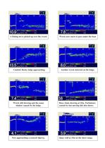
A fishing net is picked up over the wreck Caution! Rocky ledge approaching. Wreck still showing and the sonar shadow caused by the ledge. Now approaching a scoured slipway. Wreck now starts to pass under the boat Another wreck detected on the ledge. Buoy chain showing at 25m. Turbulence caused by fast moving tide also shows. Quay wall at 15m on the short range.
Open the catalog to page 2All EchoPilot catalogs and brochures
 FLSBlackBox
4 Pages
 video-engine.pdf
4 Pages
 flsbronze.pdf
2 Pages
 flsplatinum.pdf
2 Pages
 bronzeplus.pdf
2 Pages
 windleaflet.pdf
2 Pages
 easyais.pdf
1 Page
 splitocb.pdf
1 Page
 easytrx.pdf
1 Page
 eresc.pdf
2 Pages
 easyis.pdf
2 Pages
 fls3d-brochure.pdf
2 Pages


Archived catalogs
 FLS Silver II Brochure
2 Pages
 FLS Gold II Brochure
2 Pages

