
- Catalogs
- CHC Navigation
- APACHE6


APACHE6

APACHE6
- Multibeam Echosounder: Optimized for NORBIT iWBMSe, iWBMS, and iWBMSh-STX series, providing high-resolution data for marine surveys.
- Optional Terrestrial Mapping: The NORBIT iLiDAR sensor allows combined marine and terrestrial 3D surveys, collecting up to 300,000 points per second.
- Lightweight Design: Constructed from macromolecule polyester carbon fiber and Kevlar fiber-glass, weighing 15 kg without sensors, facilitating easy deployment by two operators.
- Triple-Hulled Vessel: Features dual detachable floating bodies for stability in rapid currents and adaptability in shallow waters.
- Autonomous Operation: Equipped with CHCNAV absolute straight line technology for autonomous survey mode, maintaining path in adverse conditions.
- Physical Dimensions: 1.8 m x 0.55 m x 0.25 m, with a draft of 0.18 m.
- Material: Anodized aluminum, stainless steel, and carbon fiber.
- Power: Electric propulsion with a maximum motor speed of 7,000 rpm and a power consumption of 60 W.
- Battery: 9 x 24,500 mAh, 32.6 V and 1 x 15,000 mAh, 18 V, providing 2 x 2 hours of endurance at 2 m/s.
- Communication: Integrated 4G modem, UHF radio, and R/C communication with a remote control range of 1 km.
- Operating Conditions: Temperature range from -20°C to +60°C.
- Swath Coverage: 5 - 210° with a heading accuracy of 0.08°.
- Depth Range: 0.2 - 275 m with a ping rate of up to 60 Hz.
- Resolution: Horizontal accuracy of ±(8 mm + 1 ppm x distance from RTK station) and vertical accuracy of ±(15 mm + 1 ppm x distance from RTK station).
Catalog excerpts

MULTIBEAM MARINE DRONE MARINE SURVEY & CONSTRUCTION
Open the catalog to page 1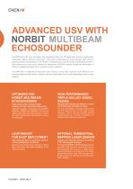
ADVANCED USV WITH NORBIT MULTIBEAM ECHOSOUNDER The APACHE 6 USV is an innovative, fully integrated solution for 3D bathymetric surveys, positioning of underwater objects, offshore construction, underwater archaeology and wreck salvage. Built around a triple-hull vessel and optimized for the Norbit™ multibeam echo sounder series, the APACHE 6 offers a fully autonomous survey mode, powered by field-proven CHCNAV absolute straight line technology, to follow a predetermined path even in adverse current conditions. The APACHE 6 multibeam echosounder USV reduces survey time, improves work efficiency...
Open the catalog to page 2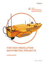
HIGH PERFORMANCE MARINE DRONE FOR HIGH RESOLUTION BATHYMETRIC PROJECTS
Open the catalog to page 3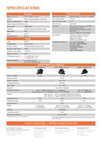
SPECIFICATIONS Communication Network bridge: 1 km and 4G: unlimited Data communication Macromolecule polyester carbon fiber Remote control range Weight (Typical instrument) 40 kg Hull material Carbon fiber Anodized Aluminum, Stainless Steel Standard Internal Rx: 410 - 470 MHz Transmit power: 0.5 W Protocol: CHC,Transparent, TT450, 3AS Satel Link rate: 9,600 bps to 19,200 bps Data formats RTCM2.x, RTCM3.x, CMR input HCN, HRC, RINEX2.11, 3.02 NMEA 0183 output NTRIP Client, NTRIP Caster LTE FDD: B1/B3/B5/B8 LTE TDD: B38/B39/B40/B41 WCDMA: B1/B8 TD-SCDMA: B34/B39 CDMA: BC0 GSM: 900/1,800 MHz Water...
Open the catalog to page 4All CHC Navigation catalogs and brochures
 3D Bathymetry via USV
6 Pages
 D230
D2304 Pages
 D390
D3904 Pages
 APACHE3
4 Pages
 APACHE4
4 Pages