
- Catalogs
- CHC Navigation
- 3D Bathymetry via USV


3D Bathymetry via USV

3D Bathymetry via USV
The document discusses the use of an Unmanned Surface Vessel (USV) equipped with a multibeam echosounder for conducting 3D bathymetric surveys of the Donghai Bridge in Shanghai, China. The primary goal is to assess the underwater conditions of bridge piers to determine the need for additional protective measures.
Specifications and Equipment
The survey utilized the APACHEG6 USV from CHCNAV, integrated with a NORBIT iWBMS STX multibeam echosounder. The USV's design includes a carbon-fiber/resin composite hull for durability and a detachable trimaran design for stability in various marine conditions. It is lightweight, portable, and can be deployed by two people.
Operational Capabilities
The USV features advanced technologies such as adaptive propulsion, stationary hovering, and inertial navigation, allowing it to operate in both manual and automatic modes. It can maintain a precise course with a trajectory deviation of less than 20 cm, ensuring high data accuracy.
Survey Procedures
The survey was completed in under an hour, with the USV operating in manual mode near bridge piers for additional data collection. The data was post-processed to identify areas requiring further investigation.
Results and Analysis
The survey identified 18 piles for further maintenance investigation. The data was compared with original construction designs to assess the need for additional riprap.
Conclusion
USVs like the APACHE6 offer significant advantages over traditional manned vessels, including reduced survey time, improved efficiency, and high-resolution data. They are particularly useful for mapping dense underwater structures and challenging environments.
Author Information
Taxiya Wang has been involved in the development of CHCNAV's international marine business since 2017, focusing on USV solutions for bathymetry and hydrological surveys.
Catalog excerpts
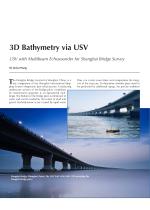
3D Bathymetry via USV USV with Multibeam Echosounder for Shanghai Bridge Survey By Taxiya Wang he Donghai Bridge, located in Shanghai, China, is a key component of the Shanghai International Shipping Center's deepwater port infrastructure. Conducting underwater surveys of the bridge piers” conditions for maintenance purposes is an operational challenge. The bottom of the bridge piers is immersed in water and can be eroded by the action of sand and gravel. Hydrodynamic scour caused by rapid water Donghai Bridge, Shanghai. (Inset) The CHCNAV APA Donghai Bridge piers. - flow can create scour holes...
Open the catalog to page 2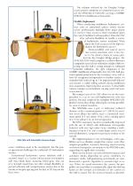
solution selected for the Donghai Bridge project comprises an unmanned survey vesAPACHEG6 of CHCNAY, carrying a NORBIT STX multibeam echosounder. Flexible Deployment When conducting multibeam bathymetric surveys with an unmanned surface vessel, marine survey professionals highlight three major points of concern: secure is their investment given the cost of multibeam echosounders? Does the USV offer sufficient flexibility to handle a variety of bathymetric survey scenarios? What about the final accuracy of the high-resolution 3D bathymetric survey? Maneuverability and ease of use in fast current...
Open the catalog to page 3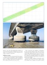
(Top) Typical linear navigation course for multibeam echosounding. (Bottom) The APACHE6 USV approaching a bridge pier. During a turn, the hull automatically decelerates so that the unmanned vessel's sounding line is at the same height as the intended line to ensure underwater data integrity throughout an operation. Multibeam Coverage Marine drones have to incorporate efficient automatic navigation control technology to follow the planned route in a complex working environment, with different speeds and changes in flow direction. The objective is to have a trajectory deviation of less than 20...
Open the catalog to page 4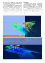
surface sound velocity and other data can be transmitted with a single interface cable for easy installation and use and to minimize the risk of damage. When the USV is stationary, the STX multibeam echosounder, in addition to its 210° horizontal scan cover- age, also has 20° longitudinal scan coverage, so that the real-time dynamic 3D scanning effect can be achieved. During multibeam sounding, the USV moves along the sounding line at a controlled constant speed of 4 to 6 kt. The display, control and data acquisition software that supports multibeam sounding runs on the data acquisition computer...
Open the catalog to page 5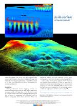
(Top) Bridge section piling and water bottom scouring rendering. (Bottom) view underwater scour details. tained throughout this survey with the original bridge construction design to determine if additional riprap was required. After data post-processing and analysis, a total of 18 piles were identified for further investigation for routine maintenance. difficult to achieve this with traditional crewed hydrographers now have the option of deploying USVs. USVs reduce survey time, improve work efficiency and produce high-resolution 3D data to meet the requirements of the most demanding marine infrastructure...
Open the catalog to page 6


