カタログの抜粋
GeoSwath Plus Wide swath bathymetry and georeferenced side scan www.kongsberg.com
カタログの1ページ目を開く
CeoSwath Plus Wide Swath Bathymetry and co-registered georeferenced side scan system marine performance by providing the Full Picture We shall earn the respect and recognition for our dedication to provide innovative and reliable marine electronics that ensure optimal operation at sea. By utilising and integrating our technology, experience and competencies in positioning, hydro a cou sties, communication, control, navigation, simulation, and automation, we aim to give our customers The Full Picture. The Full Picture yields professional solutions and global services that make a difference...
カタログの2ページ目を開く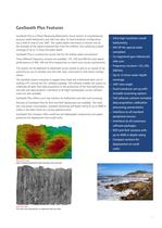
CeoSwath Plus Features • Ultra high resolution swath • Co-registered geo-referenced side scan • Up to 12 times water depth • Dual transducer set-up with versatile mounting options • Full software solution included: data acquisition, calibration processing, presentation peripheral sensors software packages CeoSwath Plus is a Phase Measuring Bathymétrie Sonar System. It simultaneously acquires swath bathymetry and side scan data. Its dual transducer configuration has a field of view of over 240°. The usable depth information is limited only by the strength of the signal scattered back from...
カタログの3ページ目を開く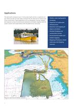
• Shallowwater hydrographie construction surveys habitat mapping • Mapping of harbours, inland The wide swath coverage of up to 12 times water depth and the co-registered and geo-referenced side scan data makes CeoSwath Plus the ideal tool for shallow water survey environments. Typical applications such as hydrographie charting, dredging and inspection surveys to environmental assessment and habitat mapping make the system a proven and trusted solution with the global survey community.
カタログの4ページ目を開く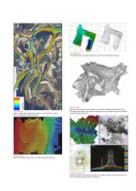
River Surveys Often a single pass is sufficient to map a river from bank to bank. NGU - Norwegian Geological Service. Sand wave fields in the vicinity of a planned harbour entrance Dredging survey Port maintenance and object detection in the Port of Trondheim, Norway. Side Scan data draped over the digital terrain model showing sediment infill into a Norwegian Fjord. NGU- Norwegian Geological Service. The data has been normalised using GeoTexture software. Infrastructure survey Imaging of pillars and sediment features of a bridge crossing. The side scan data has been normalised using...
カタログの5ページ目を開く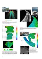
Infrastructure survey Surveying Fremont Canal, Seattle, WA. The viewing angle of 240° and the wide sea floor coverage allow mapping of the waterway from the bottom to the surface in a single pass. The 40 m wide and 10 m deep canal links Salmon Bay and Lake Union. Habitat mapping of Posidonia sea grass meadows in the Mediterranean. Posidonia plays an important role for the marine ecosystem. Its presence is revealed in the geo-referenced side scan data, simultaneously obtained with the high resolution bathymetry data. Infrastructure survey Survey of supply pipelines in The Solent, linking the...
カタログの6ページ目を開く
System Configuration GeoSwath Plus Deck Unit • Deck unit and dual transducer head included • Interfaces to all major peripheral sensors • Motion compensation GPS Position and Heading • Sound velocity compensation • Tide compensation • Geo-referencing tide information SVP sound velocity profiles GeoSwath Plus Transducer V-Plate with MRU, MiniSVS sound velocity sensor and altimeter The GeoSwath Plus turn-key solution comprises a dual transducer head with versatile mounting options together with a deck unit containing the complete sonar electronics together with a high spec PC, running the GS+...
カタログの7ページ目を開く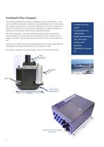
CeoSwath Plus Compact The portable CeoSwath Plus Compact is designed for small craft operation. It com- prises a modified dual transducer head and a splash protected deck unit, containing the complete sonar electronics, which are interfaced via an Ethernet connection to a laptop PC running the CS+ survey software. Optionally it can also be operated as a stand alone unit with splash proof monitor, keyboard and mouse. The head incorporates a port and starboard integrated transducer as well the required ancillary sensors and can be pre-calibrated. Due to its minimal size and weight of less...
カタログの8ページ目を開く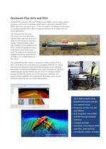
CeoSwath Plus payloads with depth ratings of up to 4000 m can be readily integrat- ed into any autonomous underwater vehicle (AUV) or Remotely Operated Vehicle (ROV). With data coverage of up to 12 times the vehicle's fly altitude and low power consumption CeoSwath Plus offers unsurpassed efficiency for all military and civil survey applications. The CeoSwath Plus AUV hous- ing contains the sonar electronics together with a high-spec small form factor PC and memory for local data storage. Operating mode is either free running or via an interface to the AUV's control and peripheral sensors...
カタログの9ページ目を開く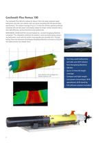
GeoSwath Plus Remus 100 The GeoSwath Plus 500 kHz module for Remus 100 is the ideal combined swath bathymetry and side scan solution with accuracies exceeding IHO-44 Special Order specifications. The seabed coverage of up to 12 times the vehicles operating altitude combined with the low power consumption allows for longer mission duration with a very high efficiency, giving enhanced survey productivity. KONCSBERC CEOACOUSTICS Ltd and Hydroid Inc. are both Kongsberg Maritime companies. This integration combines the industry's most successful phase measur- ing bathymétrie sonar with the...
カタログの10ページ目を開く
CeoSwath Plus Software CeoSwath Plus is supplied with a complete software package for data acquisition, system calibration, data processing and generation of digital terrain models as well asside scan mosaics. Data quality control and visualisation are also an important CeoSwath Plus can also be operated via Ethernet connection by third party hydro- graphic survey software. Data can be exported in most standard formats allowing it to be processed, visual- ised and incorporated into many processing streams. This includes the Generic Sen- sor Format, allowing CUBE processing algorithms to be...
カタログの11ページ目を開くKongsberg Maritime/コングスバーグのすべてのカタログとパンフレット
-
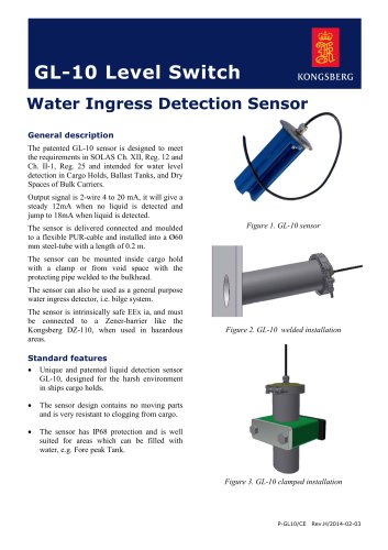 GL-10
GL-102 ページ
-
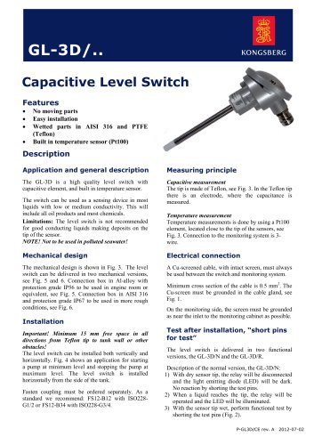 GL-3D
GL-3D4 ページ
-
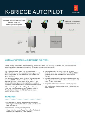 K-Bridge AP
2 ページ
-
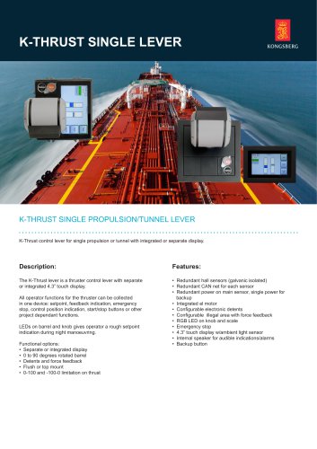 K-THRUST
2 ページ
-
 GL-7B
GL-7B2 ページ
-
 μPAP
μPAP3 ページ
-
 cNODE® Modem MiniS
2 ページ
-
 Sounder
1 ページ
-
 AutoChief 600
2 ページ
-
 DP Logger
2 ページ
-
 K-Thrust TC
4 ページ
-
 K-Thrust RCS
2 ページ
-
 cC-1
cC-12 ページ
-
 cJoy WT
2 ページ
-
 cJoy OT
2 ページ
-
 cJoy Controller
2 ページ
-
 cJoy PE
2 ページ


カタログアーカイブ
-
 EM 2040C MKII
2 ページ
-
 DRS 500/IMS 500
2 ページ
-
 The Seapath family
12 ページ
-
 mini MRU
2 ページ
-
 Company brochure
19 ページ
-
 company borchure 2019
13 ページ
-
 MGC R2
2 ページ
-
 DP alert system
2 ページ
-
 Automatic DP alert
2 ページ
-
 EELUME500
2 ページ
-
 REMUS 6000
2 ページ
-
 REMUS 600
2 ページ
-
 Naval AUV product range
16 ページ
-
 Munin AUV
2 ページ
-
 SEAGLIDER
2 ページ
-
 SEAGLIDER C2
2 ページ
-
 SEAGLIDER M6
2 ページ
-
 HISAS 1030
12 ページ
-
 KM-workboats-folder
4 ページ
-
 KM OSV brochure
8 ページ
-
 HiPAP Family brochure
24 ページ
-
 REMUS catalog
8 ページ
-
 OE14-408
2 ページ
-
 OE14-110/111
2 ページ
-
 oe15-108/109
2 ページ
-
 OE15-110/111
2 ページ
-
 Hugin family of AUV's
28 ページ
-
 Motion Gyro Compass
2 ページ
-
 Kongsberg GlobalSim
5 ページ
-
 K-CHIEF 700
9 ページ
-
 K-CHIEF 600
4 ページ
-
 OE14-372/373
1 ページ
-
 OE14-364/365
1 ページ
-
 OE14-308
1 ページ
-
 OE14-208
1 ページ
-
 oe15-358/359
1 ページ
-
 OE15-100c/101c
1 ページ
-
 OE13-124/125
2 ページ
-
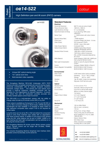
 OE14-522
1 ページ
-
 oe14-502
1 ページ
-
 AIS 200
2 ページ
-
 HPR 418
2 ページ
-
 HPR 408S
2 ページ
-
 RADius
2 ページ
-
 DPC-3
DPC-32 ページ
-
 DPC-1
DPC-12 ページ
-
 OS-650-DP
2 ページ
-
 DARPS 116
2 ページ
-
 REMUS 100
6 ページ
-
 AIS 200 BF
2 ページ
-
 Engine Room Simulator
16 ページ
-
 Pressure sensors
5 ページ
-
 Signal converters
5 ページ
-
 Products for tankers
32 ページ
-
 LNG vessel automation
12 ページ
-
 Cruise
20 ページ
-
 Yacht brochure
12 ページ
-
 K-MASTER WORKSTATION
12 ページ
-
 cJoy system
2 ページ
-
 AIS 200 P
2 ページ